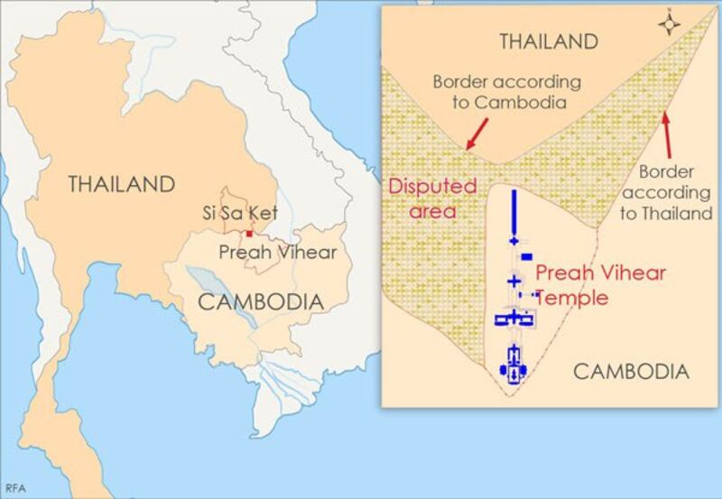
Thailand accused Cambodia on Wednesday of submitting doctored maps to the International Court of Justice hearing a dispute between the two Southeast Asian neighbors over an ancient temple site along their shared border.
Thai officials also asked the top U.N. court in The Hague not to make a ruling on the territorial boundaries surrounding the long-running feud over land around the 11th-century Preah Vihear temple.
Testifying at the hearing, Thai Ambassador to the Netherlands Virachai Plasai, who is also head of the country’s delegation, said that the court should refuse to rule on the territorial dispute because in 1962 it had refused to delineate the border.
The ICJ began a week of hearings on the dispute on Monday after Phnom Penh asked for a reinterpretation of the court’s 1962 ruling that awarded possession of the temple to Cambodia, but did not take into account the now-disputed 4.6 square kilometers (1.8 square miles) of land surrounding it.
Cambodia had not objected to the original ruling until 2008, when the temple was designated a UNESCO World Heritage site, Virachai said.
And now, more than 50 years after the 1962 ruling, “the court is asked to give, under the guise of interpretation, a declaration which the court then expressly declined to give,” he said.
The Thai legal team argued that Cambodia’s “real request” was about reinterpreting the original ruling its own favor, rather than about any ambiguities in the original ruling.
“It is an attempt to refashion the 1962 judgment to obtain a ruling that the court refused to make in 1962,” lawyer for the Thai delegation David McRae told the court.

The Thai delegation argued that there were problems with maps Cambodia had submitted to the court, accusing Cambodia of misleading the court by using falsified maps to back its claims.
Cambodian Foreign Minister Hor Namhong rejected the claims, accusing Thailand of presenting incorrect maps.
“They use many maps that were not used by the ICJ to issue the 1962 judgment. They use different reasons that are irrelevant to the law,” he told RFA’s Khmer Service after Wednesday’s hearing.
“Thailand used different excuses. Their argument is contradictory to the truth.”
Virachai said a map of the area that Cambodia used in its presentation to the hearing on Monday differed from one attached in its petition to the court.
Thai Foreign Minister Surapong Tovichakchaikul said Cambodia also switched the map that the Thai side presented to the court in the old case, and that border lines on Cambodia's maps do not match actual land, according to the Bangkok Post.
After this week’s hearings, the ICJ will likely issue a decision on the dispute within six months.
Thailand and Cambodia have exchanged several rounds of fire since 2008, when the temple, located atop a cliff in the Dangrek Mountains, was designated a UNESCO World Heritage Site.
The latest clashes left 10 dead in February 2011 and 18 dead in April that year.
Both countries pulled hundreds of soldiers out of the area last July, a year after the ICJ asked the two countries to demilitarize the disputed zone and replace the soldiers with police and security guards pending this week’s hearing.
While the site has since been free from bloodshed, tensions over the temple boundaries remain.
In southern Thailand's Si Sa Ket province, demonstrators at a national park adjacent to Preah Vihear held a rally on Wednesday aiming to raise the Thai flag over the patch of land surrounding the temple, but were stopped by some 200 Thai police, The Nation newspaper reported.
Reported by RFA’s Khmer Service. Translated by Sok Ry Sum. Written in English by Rachel Vandenbrink.
