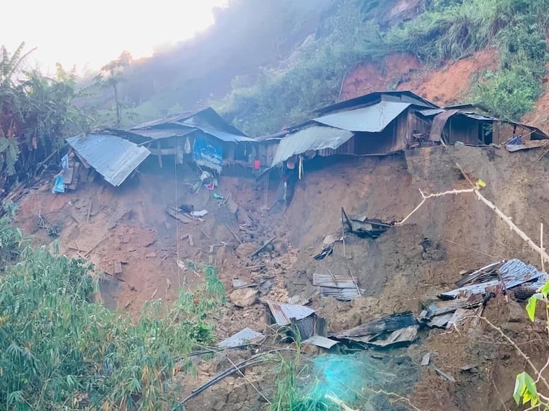
The recent landslides in Vietnam that killed hundreds are a direct result of deforestation caused mainly by hydropower development projects, deputies in the country’s national assembly said.
During a meeting of the assembly on Nov. 4, the deputies presented findings that construction on 25 large-scale hydropower plants in Vietnam’s central highlands region destroyed 68,000 hectares (263 square miles) and displaced 26,000 households.
Additionally, increased water pressure in reservoirs and dams has caused small and medium earthquakes in the region in recent years.
At the end of 2019, Vietnam’s total forested area amounted to 14.61 million hectares (56,000 square miles), 10.29 million hectares (40,000 square miles) of which were planted. The deputies questioned the quality of 40 percent of the planted forests.
Typhoon Molave, which was the most powerful storm to hit Vietnam in 20 years, slammed into the central region Oct. 28, with heavy rainfall and winds as high as 115-135 km per hour, according to data provided by Vietnam’s National Center for Hydro-Meteorological Forecasting.
The typhoon hit central regions already devastated by weeks of heavy rains, floods, and landslides beginning Oct. 6 that left at least 130 dead and thousands displaced. The floods and landslides also wrecked highways and roads, blocking efforts to rescue and bring supplies to many cut off from help in remote areas.
“The cause of the landslides is heavy rains from tropical storms that have continuously hit us for over a month,” Tran Tan Van, the director of the Vietnam Institute of Geosciences and Mineral Resources was quoted as saying on a government website.
“Additionally, in 2019, the El Niño weather phenomenon led to a prolonged drought in the central region, which caused changes in the rock and soil structure and led to greater porosity in the ground. This year, the La Niña weather phenomenon is causing heavy rains, leading to weakened soil cohesion and an underdevelopment in the root system in the mountainous region,” he said.
“Heavy rains could therefore easily cause landslides. Our research shows that just 100 millimeters [3.93 inches] of rainfall or even less could saturate the soil,” said Tran.

Tran also said that the government has set up landslide forecasting maps in 17 of Vietnam’s 37 high-risk provinces. The institute also investigated erosion and sent warnings to various localities.
Trade and Industry Minister Tran Tuan Anh, meanwhile, explained to lawmakers the impact of hydropower projects on deforestation.
“We currently have 429 active hydropower dams, or small to large sized hydropower projects nationwide, with a water storage capacity of 56 billion cubic meters, capable of generating 20,000 megawatts, which account for 37 percent of the country’s power generation capacity,” he said.
“Hydropower is an important energy source for socio-economic development in that it helps to meet the people’s power demands with a renewable energy source, with a lower risk level for pollution,” he added.
Acknowledging that the dams contributed to deforestation, the minister noted that since 2016, agencies have stopped approving hydropower projects on land that is naturally forested.
He said that 472 hydropower plant projects in the country’s central region have been cancelled due to concerns over floods and landslides in the region.
“For the last few years, there were many hydropower projects built on natural forestland, which has caused an impact on the watershed and forests… So, from now, the ministry will ask the government to tighten hydropower plant-related activities, to limit any negative impact on the environment.”
In addition to hydropower and other development projects, illegal logging is a major cause of deforestation in Vietnam.
A Viêt Nam News report published in May said that many people who lost their as a result of the effects of climate change had resorted to illegal logging, even in protected forests.
The report noted that a “lack of sanctions to monitor migration flows and stop forestry land from being illegally traded” created loopholes that contributed to deforestation, especially in the central highland region of the country.
According to Global Forest Watch, Vietnam lost about 17 percent of its tree cover between 2001 and 2019, equal to about 2.86 million hectares (11,000 square miles), capable of absorbing 1.03 gigatons of carbon dioxide emissions.
About 62 percent of this was a result of mostly “commodity driven deforestation,” with shifting agriculture, and urbanization also listed as causes.
Reported by RFA’s Vietnamese Service. Translated by Huy Le. Written in English by Eugene Whong.
